
As the name says, the rock looks like elephant. This is a naturally formed rock in Heimaey, Iceland. Heimaey is an Island in Iceland. Heimaey is the most populated island of Iceland. Iceland doesn't have any native people like the Americas or Greenland. People were migrated to Iceland from other continents. The first people to come to to Iceland were Celtic monks followed by the Vikings. In 1973, lava flow from nearby Eldfell destroyed half of the town and threatened to close off its harbor, its main income source. An operation to cool the advancing lava with sea water was successful in preventing the loss of the harbor.The 660 feet high volcano could potentially be the cause of the Elephant Rock and many other formations like it around the island.
Cartography - A study of making maps
 Cartography, Few of us would have already heard of this word and for few it would be a new terminology. Cartography is the study of making maps. The maps would be modeled in such a way that includes science, Aesthetics, and techniques so that the maps should communicate the spatial information correctly. The traditional Cartography involves setting the Map agenda which involves physical objects to be mapped in the layout such as roads, land masses, boundaries.
The Cartography can be of 2 types:
1. General Cartography
2. Thematic Cartography
General Cartography is for creating maps for the general people which have variety of features like roads, streets, boundaries.
Thematic Cartography is based on the geographic themes and only oriented toward specific audiences. For example: Corn Production in a Country or State. Nowadays we have "Heap map" that also would come under this category
There is one more category which combines these above said 2 types they are called "Orienteering" Maps.
While designing the map based on the Cartography, everyone should consider all the aspects of the Cartography and proceed further. If a Cartographer does not considered all aspects then it would lead to failure of the Cartography.
There are naming Conventions are also currently following by Cartographers. They used the regional languages wherever applicable.
Map coloring also plays a major role in making maps. Using different colors/Hue will create a confusion on map readers. The Cartographer needs to use quantity symbols wherever required. The perfectly completed map should show the main directions like East, West, North, South with the arrow.
Nowadays, GPS ( Global Positioning System) would lay on the core of this Cartography, If the Cartography fails then it may lead to misdirection when using GPS.
This Traditional complicated Cartography was made easy due to some technological growth such as Aerial Photography, Satellite Images, remote sensing, which will provide clear definition and latitude/longitude positions of a particular object so that the accuracy of maps were increased.
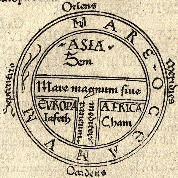
The 14th century maps would only contains the 3 continents (Africa/Europe/Asia). The other continents were included later.
Thanks for reading. You can also post your views via comments.
Subscribe to:
Posts (Atom)
Popular posts
-
 Most of the Hills in South India are dedicated to Hindu God Murugan( Arupadaiveedu), But this hill is mainly dedicated to Lord Shiva. This p...
 -
Ramzan, also known as Ramadan, is the ninth month of the Islamic lunar calendar and holds immense significance for Muslims around the world...
-
Amidst the resounding chants of ‘Govinda’ and the melodic strains of azhagar songs, Lord Kallazhagar, mounted on his golden horse vahanam, ...
-
Carrots are not just a crunchy, colorful addition to salads and stews; they are also a staple vegetable consumed worldwide, known for their...
-
Introduction: Nestled in the historic city of Bethlehem, the Church of the Nativity stands as a timeless symbol of faith and a testament to...
